Menu

domingo, 16 de julio de 2017

Vía Merche, Peña Escuach, Panticosa, Huesca, España

Merche Route, Peña Escuach, Panticosa, Huesca, Spain


En nuestro último día de esta semana de escalada decidimos hacer algo corto, porque la idea era volver a comer a Zaragoza.
En torno  a las 6 de la mañana salimos de Canfranc con direccion Panticosa, para escalar la vía Merche en la Peña Escuach, una vía equipada en el 2005 por Julio Armesto y Salvador Lopez.
On our last day of this climbing week, we decided to climb something short, because the plan was being in Zaragoza for lunch.  
At about 6 o'clock we left Canfranc heading to Panticosa, to climb the "Merche route", on the Peña Escuach of Panticosa village (not the health resort), a well-equipped route opened by Julio Armesto y Salvador Lopez in 2005.

El camino se encuentra en unos raíles metálicos que ascienden pegados a una gran tubería. Tras unos 50 metros de subida, hay un pequeño hito de piedra, indicando que el camino va por debajo de la gran tubería. Tras la tubería hay un sendero que se adentra en un corto bosque. Al acabar el bosque se llega a la zona de las paredes, hay una sirga para ayudar a llegar al principio de la vía Merche.
The track is on a rail that goes next to a big pipe. After about 50 meters climb, there is a small boundary marker, where the track turns left and goes under the big pipe. Once passed the pipe there is a footpath which goes into a little forest. The wall is just at the end of the forest, there is a rope to help to reach to the base of the "Merche route".


La vía consta de 5 largos, esta muy bien equipada, con tramos que varían entre el III y 6a, con buena roca, ademas ofrece una magnificas vistas de Peña Telera, Panticosa, pico Sabocos, etc.
The route has 5 pitches it is very well equipped with many parts of different levels, between III and 6a. Also there is a magnificent view of Peña Telera, Panticosa village, Sabocos pic etc.


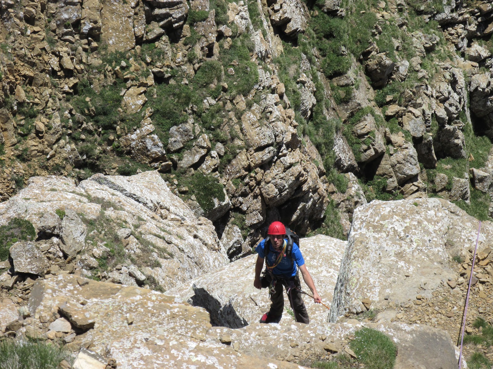
Largo 1: Empieza en una placa sencilla, para después realizar una travesía a la derecha que acaba en otra placa más vertical con el paso más difícil de la vía. Después se tumba un poco, hasta llegar a la reunión.
Pitch 1: The route starts on an easy slab, just after the slab there is a traverse to the right which ends at the bottom of a vertical slab where the most difficult part of the route is. The belay station is just after the slab.

Largo 2: La vía sigue por una canal entre bog.
Pitch 2: The route carries on for a groove which goes between boxwood plants.

Largo 3: Se inicia en una placa vertical (posibilidad de pasar por la derecha), luego se tumba hasta llegar a un corto muro vertical que nos deposita en la reunión.
Pitch 3: It starts on a vertical slab (there is a chance of avoiding this part going to the right), afterwards loses inclination until it gets to a short vertical wall that ends where the belay station is.

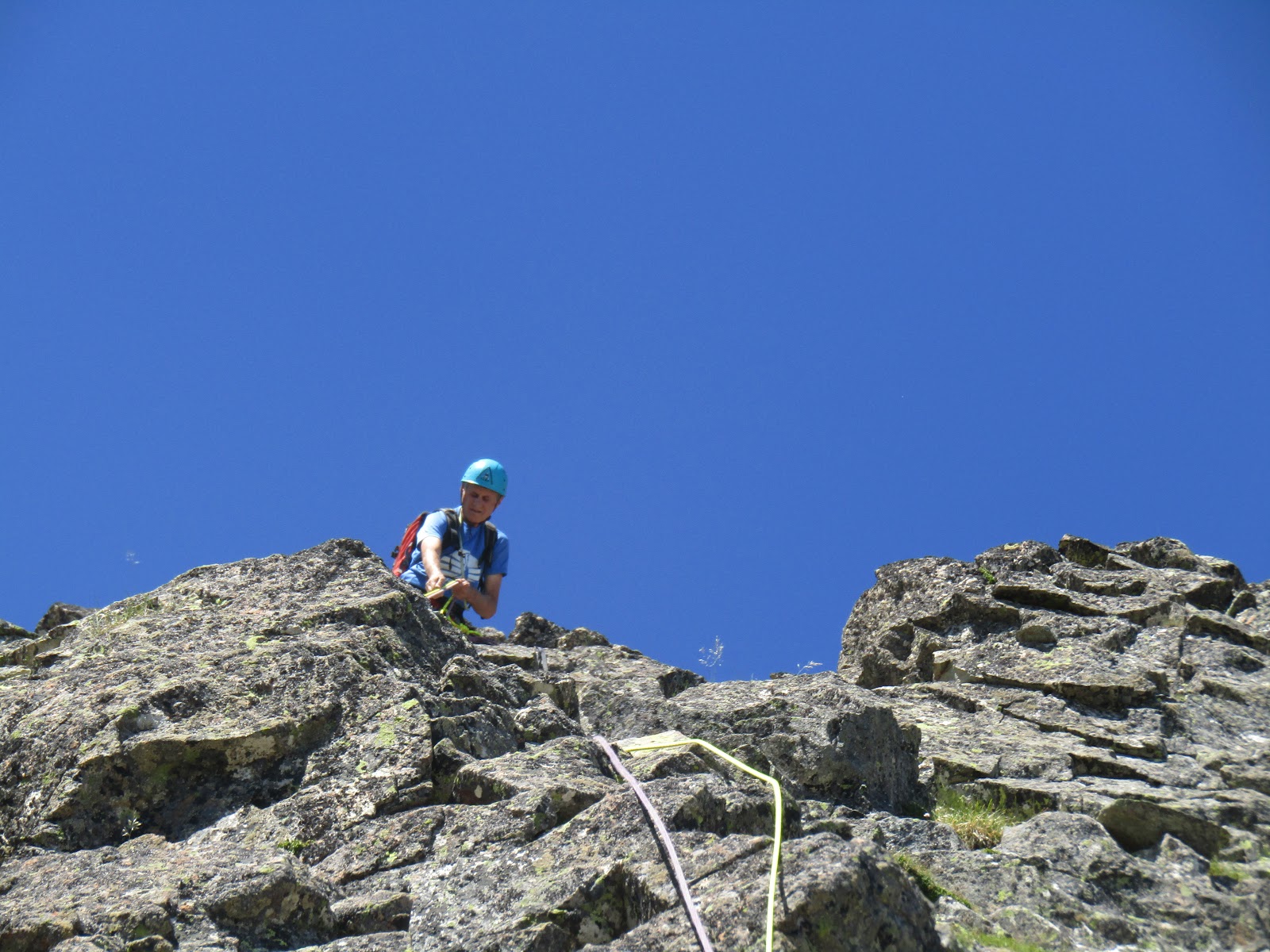
Largo 4: La via continua por una sucesión de placas, fáciles al principio, hasta llegar a un diedro, con el paso más difícil del largo, continuamos por placas más difíciles hasta la reunión.
Pitch 4: The route continues for a succession of easy slabs until it gets to a dihedral, where the hardest part of the pitch is, once the dihedral is passed there are some slabs until the belay station.

Largo 5: Consta de una placa corta pero con un paso dificil, para alcanzar la cima.
Pitch 5: It is a short but quite hard slab to get to the top

El descenso se realiza por el barranco de la derecha de la vía, hasta llegar al bosque, donde se encuentra el camino.
The descent is through the cliff set to the right of the route, heading to the forest, where there is a footpath.


sábado, 15 de julio de 2017

Arista de los Murciélagos, Pico Aspe, Candanchú, España

Murciélagos Arete, Peak Aspe, Candanchú, Spain


En torno a las 6 salimos desde el aparcamiento de Candanchú hacia Tortiellas, subimos por las pistas de esquí hasta llegar al primer collado, donde cogimos el camino de Tortiellas a la Tuca. Una vez en el collado seguimos la pista de la Tuca, y tras pasar por debajo de la silla de la Tuca cogimos el paso de la subida normal del Aspe. Dejamos el camino cuando este se encuentra más o menos en la base del Aspe, y subimos por la parte izquierda de la montaña hasta el collado de la Garganta de Aisa.
At about 6 am we left from Candanchú's car park to "Tortiellas", we walked up through the skiing pistes until the first hill, where we took the "Tortiellas path" to the Tuca. Once on top of the hill, we followed the track to the Tuca, and just after we passed under the chairlift we took the traditional track to the Aspe. We left the path more or less at the base of the mountain, then we walked up the left side of the mountain until we got to the hill Garganta de Aisa.


Vía:
Route:


La primera placa tiene varios pitones que marcan el itinerario (max IV), acaba en una zona más tumbada, que subimos caminando hasta la base de la aguja Dondestastu.
The first slab has some pitons on the wall to indicate the route (max IV), it ends on a much flatter area, that we walked up to the base of the "Dondestastu needle".

Atacamos la aguja por un pequeño diedro-chimenea sencillo y equipado con clavos, hay a una reunión a pocos metros de la cima, pero continuamos hasta la cima donde encontramos la reunión entre los bloques.
We attacked the needle through a small and easy dihedral equipped with pitons, there is a belay station a few meters down from the top, but we continued to the top, where we there is another one between the blocks.

Desde aquí, destrepamos unos metros hasta la horquilla que da comienzo al largo más vertical de la vía. 
From here, we downclimbed a few meters until the base of the most vertical slab in the route. 

El largo es un muro aparentemente liso, (IV, clavos), con tendencia a la derecha hasta coger un canal más descompuesta que nos deja en la cima. Reunión en la cima con lazos, (largo muy bonito y con ambiente).
The slab looks smoother than it really is (IV, there are some pitons), it tends to the right until it gets to a quite broken groove. The belay station is at the top.

Continuamos por una cresta fácil, pero con muy bonitas vistas, hasta llegar a una instalación de rápel, de menos de unos 15 metros.
We carried on over an easy arete, where there is a great view of the Pyrenees, until we got to a less than 15 metres abseil point.

Después del rápel, hicimos otro largo (III/IV) que acaba en la base del gran contrafuerte final del Aspe, donde esta la reunión.
After the abseil, we climbed another slab (III/IV) which ends at the base of Aspe's great counterfort, where the belay station is.

Seguimos por la derecha, hasta llegar al pie de un pequeño resalte desplomado, protegido con cordino y clavo, donde hacemos reunión (V).
We continued to the right until we got to the base of an overhung slab, protected with a trap and a piton, we set the belay station there (V).

Superado el paso más difícil, solo queda una cresta por una amplia canal descompuesta (III), que va en travesia hacia la derecha hasta encontrar una arista, desde la cual se ve la cima, un pequeño destrepe y una trepada por la cresta, nos deja en una pequeña brecha para pasar a la cima principal.
Once done the hardest part of the route, there is only left a large and broken groove, which goes in traverse to the right, until it gets to an arete, from where the summit is finally visible. From the arete, there is a small downclimb to the arete of the summit.

Descendimos por la vía normal del Aspe.
We descended for the traditional track to the Aspe.


viernes, 14 de julio de 2017

Barranco Aguaré, Canfranc, España

Aguaré Canyon, Canfranc, Spain

Aparcamos justo enfrente de la salida del barranco,en una explanada en frente de la gasolinera de Canfranc. Bajamos al pueblo de Canfranc para coger el sendero GR11, en 1 hora llegamos a la Majada de Gabardito, seguimos un camino a la derecha y en 10 minutos llegamos a la entrada del barranco.
We parked just in front of the end of the canyon, in the esplanade in front of the petrol station. We walked down to "Canfranc Pueblo" to get the path GR11, in 1h we reached to "Majada de Gabardito", then we followed a little track towards the right, in 10 min we got to the beginning of the canyon.

El primer rápel es el más largo (25 metros). Seguimos el cauce hasta que  llegamos al 2º rápel y continuamos sorteando una zona rápeles y toboganes hasta llegar a un destrepe de troncos y un agujero en oposición.
Seguimos por una zona de bloques y gradas hasta llegar a un rápel en un árbol con una baga, a partir del 7º rápel el barranco gana en interés, se estrechay oscurece, y la sucesión de rápeles es continua hasta llegar a los 3 últimos, que son sobre muros artificiales hechos para contener el agua.
The 1st abseil is the longest one (25 meters). We followed the river until we reached to the 2nd rappel. We carried on avoiding an area with some rappels and slices until we got to a fallen log and an opposition hole. 
We continued to an easy area of blocks and natural steps until we got to an abseil set on a tree. From the 7th rappel, the canyon becomes more interesting because it gets thinner and darker, and the succession of rappels is continued until the last 3 abseils, which are on artificial walls made to contain the water.


jueves, 13 de julio de 2017

Contrafuerte Oriental, Pic Midi D´Ossau (2884m), Aquitania, Francia

Contrefort Oriental, Peak Midi D´Ossau (2884m), Aquitaine, France


En torno a las 6:30 aparcamos en el Portalet, en el aparcamiento que se encuentra justo debajo de la frontera francesa. 
At about 6:30 we parked at the Portalet car park, just below the border, in the French site.


Justo en frente del aparcamiento cogimos el camino que lleva al refugio de Pombie y Midi D´Ossau.
Just in front of the car park, we took the track to the Pombie shelter and the Midi D'Ossau.


En torno a las 8:30 llegamos a la base de la vía normal del Midi. Nos pusimos el material en una repisa que hay unos metros más arriba.
At about 8:30 we arrived at the bottom of Midi's traditional route. We put all the stuff on a slab located a few meters above the bottom.


La via comienza con una placa de adherencia fácil, continua yendo un poco hacia la derecha, hacia un diedro chimenea (IV) donde está el paso más difícil. A nuestra izquierda tenemos un pequeño pino donde montamos la reunión.
The route starts on an easy adhesion slab, after the slab the route goes a bit right towards a dihedral (IV) where the hardest part is. After the dihedral, there is a pine to set the belay station.


La ruta continua por el filo de la arista (III), hasta llegar a unas placas tumbadas y terreno fácil hasta la base de un pequeño muro (III), que conduce a la base del diedro desplomado (IV+). 
The route continues on the edge of an arete (III), after the arete, there are some flat slabs and a walkable area until the bottom of a small wall (III) which ends at the bottom of an overhanging dihedral (IV+).


Una vez el diedro desplomado es superado, la vía sigue a la derecha por otro Superamos un diedro, justo debajo del primer paso, se puede proteger con un friend del 2, llegamos hasta un clavo con un cordino, para continuar en la derecha por otro diedro que acaba en una amplia repisa, donde montar la reunión. 
Once the overhanging dihedral is passed, the route continues to the right through another dihedral which ends on a quite spacious slab, where set the belay station.


La ultima parte de la ruta empieza en una fisura hacia la izquierda (III) que acaba en lo alto a otra repisa, hay un un clavo. Tras la repisa hay una canal que termina en la cima de una brecha, donde hay montado una rapel. El rapel es de unos 10 metros con 2 parabolt, acaba en una canal pegada al camino de la vía normal, cerca de la cruz de hierro.
The last part of the route begins on a crack towards the left (III) which ends on another slab at the top, there is a piton on the wall. After the slab, there is a groove which ends on top of a ridge, where there is set an abseil point. The abseil is an about 10m long, set with two bolts. It ends in another groove close to the traditional route path, near the iron cross. 


Una ves terminada la vía, decidimos subir a la cima por la vía normal.
Once we finished the route, we decided to walk up to the summit for the normal way.