El Descanso del Guerrero Route , Riglos, Huesca
Como hacía mucho viento, Diego, mi padre y yo decidimos hacer una escalada corta, elegimos la vía El Descanso del Guerrero en el mallo Tornillo, abierta por Sueño Vertical.
As it was very windy, Diego my dad and I decided to climb a short route. We decided to climb the route “El Descanso del Guerrero” (The Rest of the Warrior), a route open by the guys from Sueño Vertical on the mallo Tornillo in Riglos.
En muchas guías a este Mallo lo suelen llamar "Tornillito" o incluso "Falso Tornillo", reservando el nombre de "Tornillo" para un Mallo que se encuentra a la derecha de la Peña de Don Justo.
In the book guides this mallo is commonly called as “Tornillito” (Little Screw) or even “Falso Tornillo” (Fake Screw), as they called Screw to another mallo located next to Peña de Don Justo.
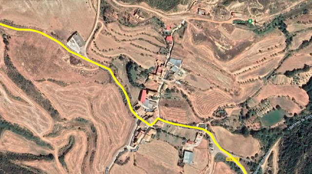
Aproximación: La manera más rápida es yendo al pueblo Linas de Marcuello. Entraremos a Linas de Marcuello, giraremos a la izquierda. y en la siguiente calle seguiremos hacia la derecha para salir del pueblo. Seguiremos por una pista ancha que comienza a descender, y después de 1 km encontraremos un cruce con un cartel (Izquierda Estación y Recto a Riglos), seguiremos rectos. 100 metros después aparcaremos antes de que la pista comience a descender, ya que a la derecha sale otra pista que se encuentra cerrada, y por la que deberemos seguir a pie.
Access: The fastest way to get there is going to the village Linas de Marcuello. Once in the village, turn left at the first junction and right at the next street to get to a wide earthy road. The road goes down and after more or less 1km (0,6 miles) there will be a junction where there is a sign, left to the Station and straight on to Riglos, take the road to Riglos. After more or less 100 meters park the car, just before the road goes downhill, to carry on by foot. On the right, there will be a closed road that you will need to take.
Seguir la pista cerrada al tráfico, durante unos 20 minutos hasta que más o menos a la altura del mallo veamos un mojón donde se encuentra el sendero que lleva hasta la base.
Follow the closed for about 20 minutes, more or less where the mallo is located there is a boundary marker to show where the little path to the base of the mallo begins.
Vía / Route:
Largo 1 (30 metros, 6a (V/A0)): Empieza en una panza, seguida de un fácil espolón escalonado que acaba en una repisa, donde encontraremos dos chapas pertenecientes al 2º rapel. La reunión se encuentra en la repisa superior, en la base de la pared.
1st Pitch (30 meters, 6a (V/A0)): It starts on a bulge, followed by an easy steppy buttress that ends on a slab, where on its edge there are 2 bolts, they belong to the 2nd abseil. The belay station is located on the upper slab, on the base of the wall.
Largo 2 (20 metros, V/A0): Empieza en un desplome seguido un muro algo terroso, que sube hacia la derecha y llega a una amplia repisa donde está la reunión.
2nd Pitch (20 meters, V/A0): Begins on an overhung, it follows a quite loose and earthy wall on which the route tends to go right to reach a big slab where the belay station is located.
Largo 3 (25 metros, V/Ae): La vía sigue por una gran panza, seguida de una pequeña travesía a la izquierda hasta una sabina. Desde allí sube por una sucesión de panzas hasta la cima. Tras superar la última habrá que gatear para llegar a la reunión y hace cima. Los estribos son muy necesarios en este largo.
3rd Pitch (25 meters, V/Ae): The route continues on a big bulge, afterwards there is a little left traverse to a sabine, from where the route becomes vertical carrying on in a succession of different sizes bulgess, once the last one has been climbed, you will have to crawl to reach the anchor and the summit. The stirrups are really necessary in this pitch.
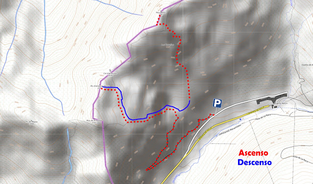
Descenso: Rapelando. Son 2 rapeles. El primero desde cima a Reunión 1 y el segundo desde el extremo de la repisa situada debajo de la de la reunión hasta la base.
Descent: Abseiling down. There are 2 abseils. The first one from the summit to the first bellay station, and the second one from the edge of the slab located just below the 1st bellay station to the base.
1º Largo / 1st pitch
2º Largo / 2nd pitch
3º Largo / 3rd pitch
Cima / Summit