Menu

jueves, 24 de febrero de 2022

Vía El Descanso del Guerrero, Riglos, Huesca

El Descanso del Guerrero Route , Riglos, Huesca


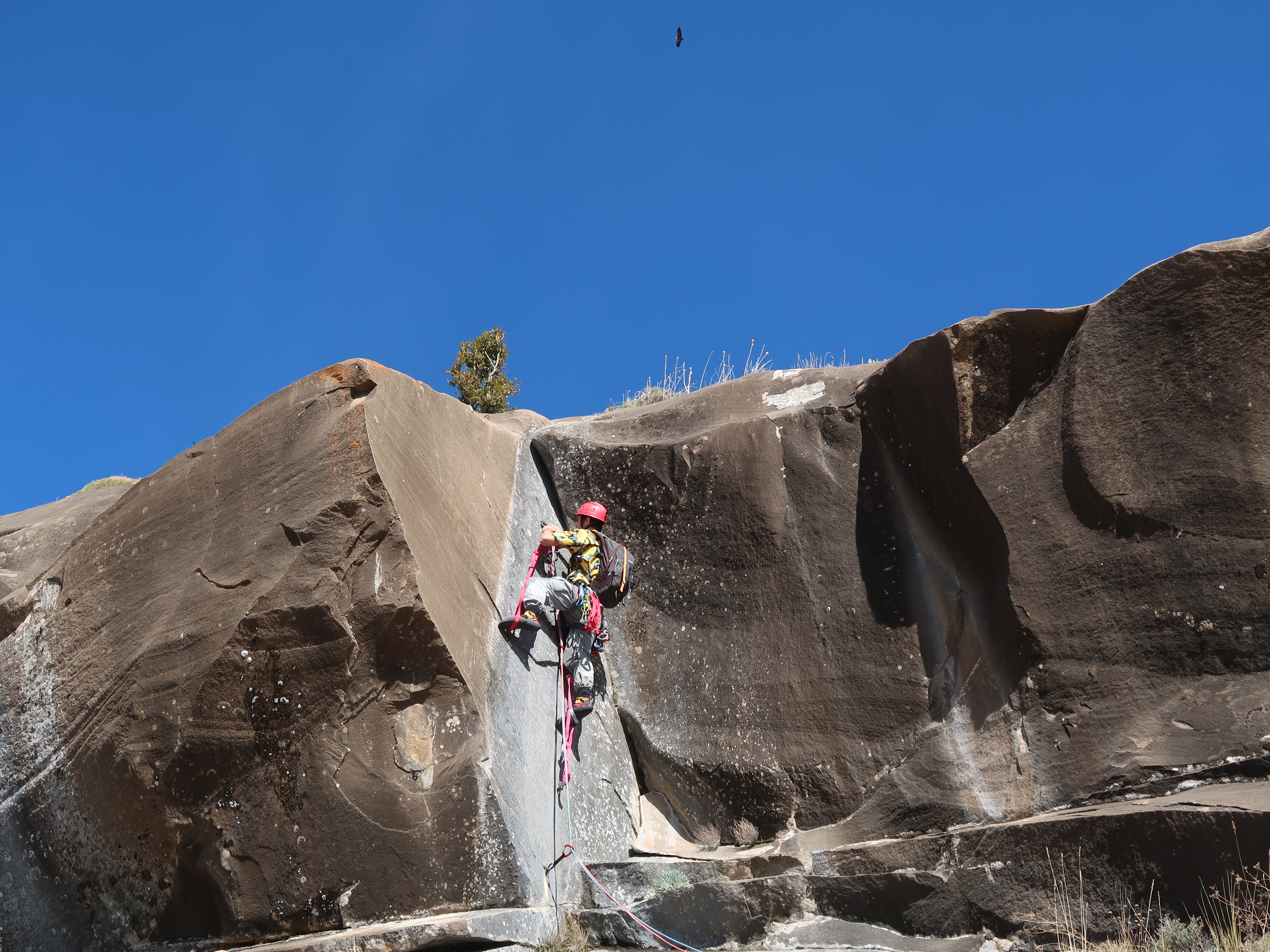
Como hacía mucho viento, Diego, mi padre y yo decidimos hacer una escalada corta, elegimos la vía El Descanso del Guerrero en el mallo Tornillo, abierta por Sueño Vertical.
As it was very windy, Diego my dad and I decided to climb a short route. We decided to climb the route “El Descanso del Guerrero” (The Rest of the Warrior), a route open by the guys from Sueño Vertical on the mallo Tornillo in Riglos. 

En muchas guías a este Mallo lo suelen llamar "Tornillito" o incluso "Falso Tornillo", reservando el nombre de "Tornillo" para un Mallo que se encuentra a la derecha de la Peña de Don Justo.
In the book guides this mallo is commonly called as “Tornillito” (Little Screw) or even “Falso Tornillo” (Fake Screw), as they called Screw to another mallo located next to Peña de Don Justo.

Aproximación:
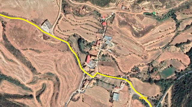
 La manera más rápida es yendo al pueblo Linas de Marcuello. Entraremos a Linas de Marcuello, giraremos a la izquierda. y en la siguiente calle seguiremos hacia la derecha para salir del pueblo. Seguiremos por una pista ancha que comienza a descender, y después de 1 km encontraremos un cruce con un cartel (Izquierda Estación y Recto a Riglos), seguiremos rectos. 100 metros después aparcaremos antes de que la pista comience a descender, ya que a la derecha sale otra pista que se encuentra cerrada, y por la que deberemos seguir a pie. 
Access: The fastest way to get there is going to the village Linas de Marcuello. Once in the village, turn left at the first junction and right at the next street to get to a wide earthy road. The road goes down and after more or less 1km (0,6 miles) there will be a junction where there is a sign, left to the Station and straight on to Riglos, take the road to Riglos. After more or less 100 meters park the car, just before the road goes downhill, to carry on by foot. On the right, there will be a closed road that you will need to take. 


Seguir la pista cerrada al tráfico, durante unos 20 minutos hasta que más o menos a la altura del mallo veamos un mojón donde se encuentra el sendero que lleva hasta la base.
Follow the closed for about 20 minutes, more or less where the mallo is located there is a boundary marker to show where the little path to the base of the mallo begins. 


Vía / Route:


Largo 1 (30 metros, 6a (V/A0)):
Empieza en una panza, seguida de un fácil espolón escalonado que acaba en una repisa, donde encontraremos dos chapas pertenecientes al 2º rapel. La reunión se encuentra en la repisa superior, en la base de la pared.
1st Pitch (30 meters, 6a (V/A0)): It starts on a bulge, followed by an easy steppy buttress that ends on a slab, where on its edge there are 2 bolts, they belong to the 2nd abseil. The belay station is located on the upper slab, on the base of the wall. 

Largo 2 (20 metros, V/A0):
Empieza en un desplome seguido un muro algo terroso, que sube hacia la derecha y llega a una amplia repisa donde está la reunión.
2nd Pitch (20 meters, V/A0): Begins on an overhung, it follows a quite loose and earthy wall on which the route tends to go right to reach a big slab where the belay station is located.

Largo 3 (25 metros, V/Ae): La vía sigue por una gran panza, seguida de una pequeña travesía a la izquierda hasta una sabina. Desde allí sube por una sucesión de panzas hasta la cima. Tras superar la última habrá que gatear para llegar a la reunión y hace cima. Los estribos son muy necesarios en este largo.
3rd Pitch (25 meters, V/Ae): The route continues on a big bulge, afterwards there is a little left traverse to a sabine, from where the route becomes vertical carrying on in a succession of different sizes bulgess, once the last one has been climbed, you will have to crawl to reach the anchor and the summit. The stirrups are really necessary in this pitch.

Descenso: Rapelando. Son 2 rapeles. El primero desde cima a Reunión 1 y el segundo desde el extremo de la repisa situada debajo de la de la reunión hasta la base.
Descent: Abseiling down. There are 2 abseils. The first one from the summit to the first bellay station, and the second one from the edge of the slab located just below the 1st bellay station to the base. 

1º Largo / 1st pitch


2º Largo / 2nd pitch


3º Largo / 3rd pitch


Cima / Summit


domingo, 20 de febrero de 2022

Ascensión a Pic d'Arnousse (2.141 m) y Bénou (2.267 m), Astún, España

Ascent to Pic d'Arnousse (2.141 m) & Bénou (2.267 m), Astun, Spain

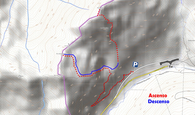
En torno a las 9 de la mañana, Diegomi padreAdriánFlor, la administradora de @pirineosadventures, y yo, aparcamos al principio del parking tierra situado en la parte alta de Astún.
At about 9 o'clock, Diegomy dadAdriánFlor, the admin of pirineosadventures as I, parked at the earthy car park located in the upper part of Astun.


Al principio del parking, sale una pista que recorremos hasta llegar a un muro de contención de aludes, desde donde giramos a la izquierda para ascender al Pico d'Arnousse (2.141 m).
At the beginning of the car park, there is a track that goes up to an avalanche retaining wall, once at the walls we turned left to ascent to Mt d'Arnousse (2141 m). 

Bajamos esquiando hasta el muro de contención de aludes (1.850 m), donde volvimos a poner pieles para subir al pico Benou. Vamos en horizontal hacia el Este hasta llegar a la parte baja del pico, al que ascendimos haciendo zetas hasta la cima (2.267 m).
Afterwards, We skied down until the avalanche retaining wall (1850 m), where we put the skins on again to climb Mt Benou. We climbed horizontally to the East until we reached the hillside of the mountain, we completed the ascent zigzagging until we got to the top (2267 m).

Descendimos por el mismo camino que habíamos subido.
We descended taking the same way we had taken to climb to the peak.


viernes, 19 de noviembre de 2021

Vía Blue Velvet, Pared de Bonés, Arguís, Huesca

 Blue Velvet route, Bonés Wall, Arguís, Huesca

A las 9 de la mañana, Diego, mi padre y yo quedamos con Flor, la administradora de @pirineosadventures en Arguís, para hacer la vía Blue Velvet en la pared de Bonés.
At about 9:30am, Diego, my dad and me met with Flor, the adm of @pirineosadventures in Arguís, to rock climb the route Blue Velvet, on the Bonés wall. 

¿Como llegar? Desde Arguís, seguir la carretera principal y tras salir del pueblo, tomar la primera salida a la izquierda, situada en una gran curva a la derecha. Tras girar, permanecer en la carretera hasta llegar a un “silo” donde se encuentra en aparcamiento.
¿How to get there? From Arguís, follow the main road and leave the village. Take the first exit to the left, it is located in a big right bend, about 500 meters away from the village. Once in the new road, follow it until reaching a “Silo”, where the car park is located.  


Aproximación: Desde el aparcamiento, seguir los mojones y flechas pintadas del sendero. En la parte de arriba, justo debajo de una pared, el sendero se bifurca, para llegar a diferentes vías, por lo que hay que tomar el sendero de la izquierda.
Access: From the car park, follow the boundary markers and arrows painted on the rock from the path. In the upper part, just below a wall, the path divides in 2, as a diversion to get to the different routes on the wall, take the one that goes to the left.

Vía / Route:


Largo 1 (55 metros, V+): Largo de placa, en ciertos puntos es algo resbaladizo, seguir la línea de parabolts que va a la derecha, ya que la otra linea pertenece a la vía “Tiza”. Reunión cómoda en una repisa
1st Pitch (55 meters, V+): Slab pitch, it gets quite slippery in some spots of the pitch, follow the line of bolts that goes right, as the another line belongs to the route “Tiza”. Quite comfortable anchor on a slab.
Largo 2 (40 metros, 6b+): Empieza en un muro con fisuras que lleva a un dihedro vertical muy difícil, nosotros usamos estribos. Hay 2 reuniones, una intermedia justo antes del dihedro y otra justo encima de este.
2nd Pitch (40 meters, 6b+): It starts on a cracked slab that leads to a very tough vertical dihedral, we had to use stirrups. There are 2 belay stations, one intermediate, just before de dihedral and the main one just above the dihedral.  

Largo 3 (35 metros, IV+): Placa tumbada.
3rd Pitch (35 meters, IV+): Lied slab.

Largo 4 (25 metros, 7a/A1): El largo más difícil y expuesto. Empieza en un dihedro (6b), hay agarres, pero resbalan bastante. Tras el diedro, hay un bonito muro vertical, que lleva al punto clave de la vía. Un muro de 7a muy difícil, en el que los parabolts están colocados de manera que hay que escalar, incluso usando estribos, recomendable el uso de tramposa (Kong Panic) para este largo.
4th Pitch (35 meters, 7a/A1): The hardest and most exposed pitch of the route. It starts on a 6b dihedral, there are holds, but they are quite slippery. After the dihedral, there is a very beautiful vertical wall that leads to the “crux” of the route. A very difficult 7a wall, the bolts are set in a way that force you to climb, even using stirrups. It is advisable to have the “Kong Panic” with you for this pitch, just in case.

Descenso: Rapelando por la vía hasta su base. Son 3 rapeles. 
Descent: Abseiling down on the route until reaching its base. We had to do 3 abseils.


sábado, 6 de noviembre de 2021

Vía Psikoterapia, Peña Predicadera, Huesca

 Vía Psikoterapia, Peña Predicadera, Huesca

En torno a las 9:30 aparcamos en el parking de la Tejería, para dirigirnos a la Peña Predicadera a escalar la vía Psikoterapia.
At about 9:30am, we parked at La Tejeria car park, as we were heading to Peña Predicadera to rock climb the route Psikoterapia.

Aproximación: Desde el aparcamiento, tomar la pista de la derecha y seguirla hasta llegar a un cruce a la derecha que lleva a la peña Predicadera. Nada más llegar al bosque, hay un pequeño camino que asciende por la colina, y lleva a 2 secciones de cuerda fija. Tras ascender por la cuerda, seguir los mojones hasta la base de la pared.
Access: From the car park, take the track on the right and follow it until reaching a junction, turn right to get to the path that takes to Peña Predicadera. Just after getting into the forest, turn left, taking the small path that goes uphill, stay in it following the boundary markers until reaching 2 sections of permanent ropes. After having climbed the last rope follow the boundary markers until the base of the wall.


Vía / Route:


Largo 1 (50 metros, IV+): Largo de placa que no presenta mucha dificultad.
1st Pitch (50 meters, IV+): Not very difficult slab pitch.

Largo 2 (35 metros, V): Empieza en una placa que lleva a una bonita chimenea con buenos agarres. Reunión justo después de la chimenea.
2nd Pitch (35 meters, V): It starts on a slab that leads to a nice chimney with good holds. Anchor just after the chimney.  

Largo 3 (35 metros, 6a): El largo más difícil y expuesto. Empieza en una pared vertical con agarres muy pequeños, se puede acerar (6a, V+/A0). Una vez superada la parte inicial hay buenos agarres en el borde izquierdo de la pared. Tras la pared de 6a, la vía continúa ascendiendo en travesía pasando de una canal a otra, parte bastante expuesta que se puede evitar subiendo al espolón y tomando la parte final del largo de la vía Jabalí Errante. Reunión justo debajo del gran techo.
3rd Pitch (35 meters, 6a): The hardest and most exposed pitch of the route.  It begins on a vertical wall with very little holds, it can be aid climbed (6a, V+/A0). Once climbed the first section of the wall, there are good holds on the left edge of the wall. After the 6a’s wall, the route carries on climbing up in traverse going from one water groove to the next one, this stretch is quite exposed, so it can be missed climbing to the buttress and using the last part of the pitch from the route “El Jabali Errante”. Belay station located under the big roof.
Largo 4 (25 metros, IV): Caminar por debajo del techo y después subir la última pared para llegar a cima 
4th Pitch (25 meters, IV): Walk carefully under the roof and afterwards climb the last wall to get to the summit.
Descenso: Siguiendo los mojones de la cima que llevan al sendero localizado en la barranquera que desciende hasta el camino principal.
Descent: Following the boundary markers on the summit that lead to the path located in the scree that goes down to the main track.